OK, Mt. Whitney was an obsession. It was an itch that just needed to be scratched.
You know I was going to drag Lloyd into this. He was afraid that if he didn't go, I would just do it myself. He was not going to let that happen. However, he thought we would need to bring someone who had more experience than we had.
Our pal, Chuck H., from the Flex days, had also been hired at UPS. He was a bona fide hiker and camper, very fit and knowledgeable. We convinced him to join us.
Lloyd commuted to Louisville from Orlando to go to work. He had a crash pad there and usually came a day early, so as not to be fatigued when he flew. He often tried to get some of the old Flex gang, who had come to UPS and moved to Louisville, together for dinner, when it worked out for him. On one of those occasions, Lloyd and I were talking about our big, planned expedition and the wife of our pal, Bobby Z. heard us and said she thought Bob would like to join us. Cool. The more the merrier, as far as I am concerned.
Bob and I needed to buy some camping equipment, so we went to Quest Outdoors (love that name and their motto, "Climb Every Mountain"), to buy our stuff. When we were there, we saw another UPS pal, Snake, and told him what was up. He said he would like to join us also. The problem was, by that time, I had obtained a permit for 5 and my brother Kevin had been considering going. We did not have an opening, unless Kevin dropped out. Snake was on standby.
I pressed Kevin to make a decision and he eventually decided to drop out, he had a knee that was surgically repaired when he was a teenager. So, 5 UPS pilots, 4 of whom were former Florida Express, were going to attempt the reach the summit of the highest mountain in the United States, excluding Alaska.
There are several ways to do that. The most common and shortest way is to hike the 11 mile Mount Whitney Trail, from Whitney Portal. That is the way we were going to do it. The next choice was to decide how many days we would take to do it. Our original plan was to take 3 days. The first day we would hike 6.3 miles to Trail Camp, at 12,000 feet. Then we would camp, leave our gear there, except what we needed for a day hike, go to the summit and then return to spend another night at Trail Camp, before returning to the Portal.

Some people do this hike in one day, but we were going to be cautious and not push our luck. Since this hike begins at 8,300 feet at Whitney Portal and climbs to 14,500 feet, we had to respect the thin air and the challenges it presents to the human body. None of us had ever been that high on a hike and did not know how it would affect our bodies.
I had been reading The Whitney Portal Store Message Board. There was a story about a group of young guys from San Diego, who were all marathon runners and very fit. They drove to the Portal, spent part of the night sleeping in the car and started up the mountain at a fast pace. At about 10,000 feet, one of the guys began to have a headache and feel a little nauseated. He pressed on. By the time he got to 12,000 feet, he was really falling behind his pals and became almost knee walking sick. His friends had to abandon their hike and help him back to a lower elevation. He recovered, but he was the one guy in the group who could not handle the rapid change to thinner air. You never know who it will be or when it will happen.
High Altitude Pulmonary Edema (HAPE) and High Altitude Cerebral Edema (HACE) are conditions that occur rarely to people who ascend to 14,500 feet or more, but they do occur. If the ascent is made too rapidly, they can occur more easily. I had been doing lots of research, including reading about attempts to climb Mount Everest. Whitney is only half the elevation of Everest, but it must be taken seriously. Everest climbers spend lots of time and energy acclimatizing to the thin air of high elevation. The base camp for Everest is at around 18,000 feet. In preparation, climbers go up to higher camps and return several times. Into Thin Air is a book by Jon Krakauer about the disastrous 1996 Everest climbing season and discusses all the issues. There has been a movie made, which was based on the book. It is not nearly as informative as the book, for someone preparing a high elevation hike. One of the important issues revealed in both the book and the movie, is the wisdom of knowing when it is appropriate to begin descending, even though you have not reached the summit.
With every member of our expedition being active airline pilots, I was a little less concerned, because we all spend lots of time at high cabin altitudes in our pressurized jets, but never as high as 10,000 feet and never exerting as much energy as a hike at those altitudes.
Lloyd, Bob and I arrived in Ontario California a day early. We were able to ride the company jumpseats there, Lloyd and Chuck from Orlando and Bob and I from Louisville. Snake would arrive early in the morning of the day we would drive to Lone Pine CA. Lone Pine is the single traffic light town on Highway 395 just east of our objective. We rented a minivan and I drove to Lone Pine.
When we arrived, we could see that the top of the great eastern wall of the Sierras was obscured by a dark cloud base and rain. We went to the hotel at which we planned to sleep when we returned after the hike. (I forgot to give them my credit card and there will be more about that later.) Our plan was to eat a meal in town and drive up the 13 mile road to Whitney Portal, while hoping that the rain would stop before we got there.

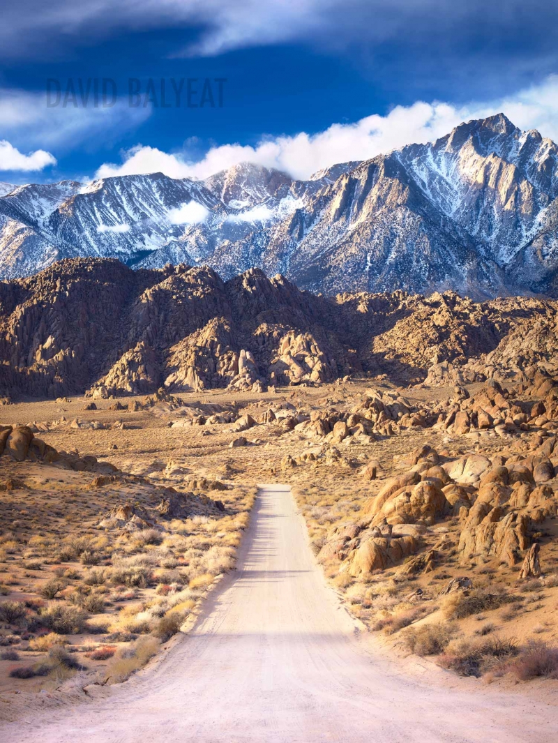
We drove west through the amazing Alabama Hills and began to climb across an open area, with the impressive Sierra wall before us. It was hard to see how we would be able to drive up there. It was not yet apparent that there was a huge switchback to the right, then back to the left, before the road entered the canyon that led to the Portal.
The cloud base was about 9 or 10 thousand feet above us, near the tops of the highest mountains. Suddenly, a two pronged bolt of lightening came down from the clouds directly in front of us and struck the ground on either side of the road. The lightening looked like the two bowed legs of a giant cowboy. The exclamations we all made highlighted the impression this event made on 5 highly experienced airline pilots and military veterans. The visual is burned in my memory-10,000 feet of lightening bolt.😮
As we recovered from our surprise, we began to see the switchback. Upon arriving at the base, we turned right and began to encounter rain. On this northbound leg, the road was in pretty good shape. As we made the 180 degree left turn to the south, we began to see that huge rocks had been washed down off the side of the mountain, creating an obstacle course for the heavily loaded minivan. Swinging left and right, we avoided all but a few smaller rocks and were concerned that the road would be closed at some point. It was not.
We found the Whitney Portal Store, parked the van and went in to do some last minute shopping and wait out the storm. I had reserved a large campground, big enough to park the van and have room for our tents. We drove the short distance after the rain stopped a few hours later. There was a small Class C camper next to us. We set up our tents, started a fire, prepared dinner and told lies and war stories. We planned our departure time and went to sleep.
Lloyd and I had identical Sierra Design 2 man tents. Bob would share mine, Chuck was with Lloyd and Snake had a little bivvy, that would have made me claustrophobic. You had to be horizontal, no sitting up in that tent. In the morning, we decided to share the weight of the 2 tents. Bob carried part of mine and Chuck carried part of Lloyd's. This would prove to be a major mistake.
I should have known better. On our previous hike together, the San Gorgonio Death March, we learned that Lloyd hikes much faster than I do, especially climbing at high elevations. On this day, it would be proven that Bob, Chuck and Snake hiked even faster than Lloyd.
I had read 3 books about hiking the Mount Whitney Trail. I was literally aware of all the landmarks on the climb and remembered most of them, at least when my brain was not fuzzed out by the thin air. Even with that, there were some psychological challenges I was not prepared for.
For the first several miles of the hike, there are several spots from which the summit is visible, if you know what to look for.
Lloyd kind of waited for me occasionally, much as he had done on the Death March. The other guys were long gone. I remember meeting a couple young guys, with whom we were doing the tortoise and hare thing. As we were climbing a set of the many, many stone steps, one of them taught me a technique I have always remembered. He said it would save energy to place the entire sole of the foot on the step, from heel to toe and use the big muscles of the upper leg to push up, as opposed to just placing the ball of the foot on the step, which requires the use of the muscles of the lower leg. The latter can be very tiring on a long climb.
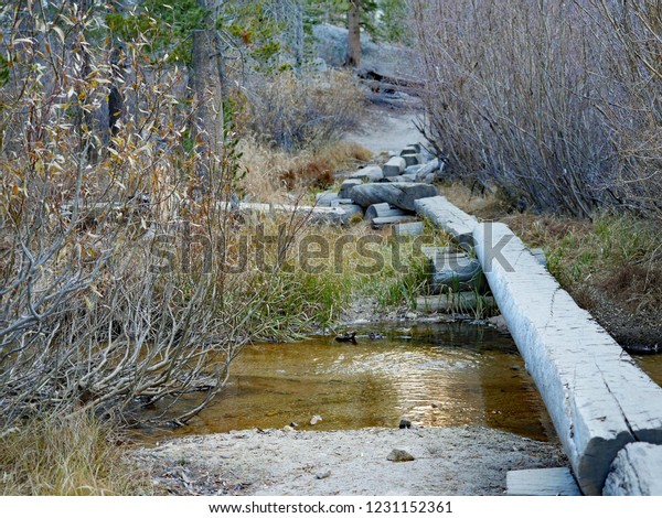
After passing the beginning of the use trail to the East Face, we traversed to the southwest and followed Lone Pine Creek. Therefore, there is water available at almost all times. Also, the view of the summit is blocked and the thoughts of how high and long this climb will be goes to the back of your mind. After several trail switchbacks, we come to a place where a log bridge was built to keep our feet dry as we walk up Lone Pine Creek in a relatively level section.
At the end of that, we pass the cut off to Lone Pine Lake. We would not be visiting this beautiful spot. I did make it up there several years later. I will show some of our photos in a later blog. Not far from there, we pass a sign that announces our entry into the Whitney Zone, which was created to protect the environment there and requires a permit to enter.
This trail is 11 miles from the Portal to the summit. The Google Map in the hyper link above shows a little less, but represents the horizontal distance, without regard to the vertical measurement. Therefore the actual distance covered is like the hypotenuse of a right triangle. (I was pretty good at plane geometry in high school and this is all I remember). As we climbed above 10,000 feet, the trail leveled for a little distance, until we passed Long Horn Meadow and Outpost Camp. Outpost camp was a primitive campsite, except for the presence of a solar outhouse. WTF is a solar outhouse, you may be inclined to ask. I know I was.
It is an environmentalist wet dream attempt to process human poop, using solar panels, in the hope that people could poop in the building, without introducing any of their urine. Even our resident environmental whacko, Snake, realized how difficult it is to "relax down there" enough to do a 2, without allowing a 1. At any rate, the system was out of service, probably because of the introduction of liquid, that was inevitable. The solar outhouse at Outpost Camp was closed. There was another at our Trail Camp, our destination for the day.
Climb, climb, climb, steps, steps, steps, waterbars, waterbars, waterbars, rocks, rocks, rocks, switchbacks, switchbacks, switchbacks. Another small respite at Trailside Meadow, before the final climb to Trail Camp, at 12,000 feet and 6.3 miles up the trail. This is where Lloyd and I were when we first encountered the rain of the day. This was before I began to remember times, so that I could calculate my speed in miles per hour, but I'm betting it was not much faster than 1mph, with my backpacking load.
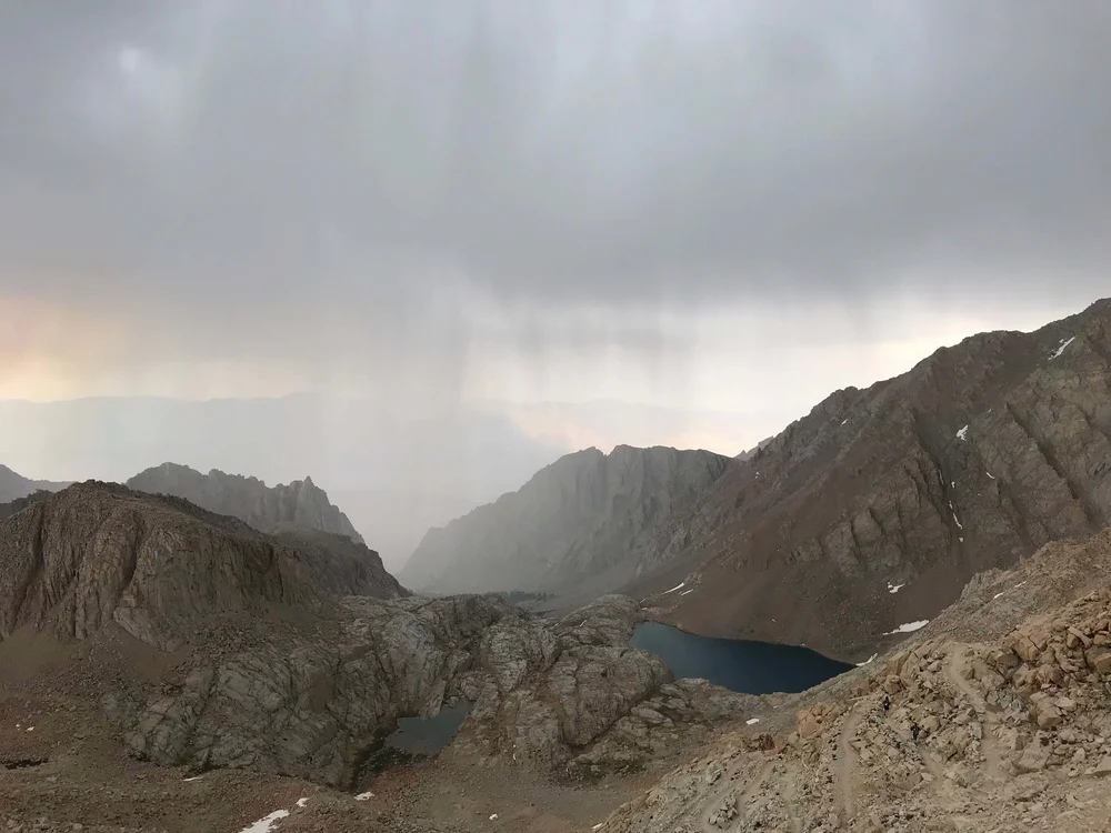
Just before reaching the level, rocky spot that is known as Trail Camp, we could see Consultation Lake off the trail to the south. I always get a kick out of hearing people mispronounce that name. Thank you Sisters Of St. Joseph for making me a nerd about things like that. By that time, it was raining like hell. Actually, we were walking into it and our much faster pals, who mercilessly left us in the dust, had been standing there in the cool ambient air, getting drenched, with only part of each of the 2 man, Sierra Design tents. Ha!
Seriously it was not a pleasant situation. They had scouted out good spots for us to set up our tents. As I pulled my share of my tent and Bob pulled out his share, I heard Snake say, "I don't want to seem melodramatic, but this may be a survival situation". I said, "I don't think you are being melodramatic, it is a survival situation". My hands were shaking from my much briefer exposure to the cold, wet conditions and it was hard to articulate the process necessary to set up the tent. Hypothermia was a real possibility.
Long story short, we got the tents up, got inside, changed into dry clothes and the rain stopped early enough for us to pump some water from the nearby pond and prepare our evening meal. We heard what I thought was a jet flying over. Snake was the first to realize it was a giant rock slide from the wall to the southwest of Consultation Lake.
As Lloyd and I were on the final struggle to Trail Camp, the other 3 guys had been talking to other people there. Some of them had tried going up the next section of trail, known as the 99 Switchbacks and decided to retreat in the face of the storm. As they climbed into colder air, there was ice forming at a difficult section known as the Cables. No one came out and said it, but I could sense that my pals were in the early stages of deciding to turn back for the trailhead in the morning, instead of pressing on to the summit. I was very disappointed, even though I knew that I was the slowest hiker. I had learned my lesson from reading Into Thin Air and from my own Death March experience. I would turn back if that was what the group decided, but I would have great regrets for not "going and taking a look at it". Pilots can relate to that quote.
As I often say, darkness comes early to the east side of a mountain. As my spirit was at its lowest, Chuck pulled out a flask of Scotch, passed it around and said, "Take a swig of this, get in your sleeping bag and go to sleep. Set your alarms for 4 AM. We are going to the summit tomorrow morning". I love that guy. At Florida Express, he was a good friend, who was known for quietly and efficiently getting the job done, unlike some of the s#!t magnets we had there. He literally made this trip for me in that 1 minute, inspirational speech. The other guys would have to have exposed their pu$$ine$$ to argue with that.
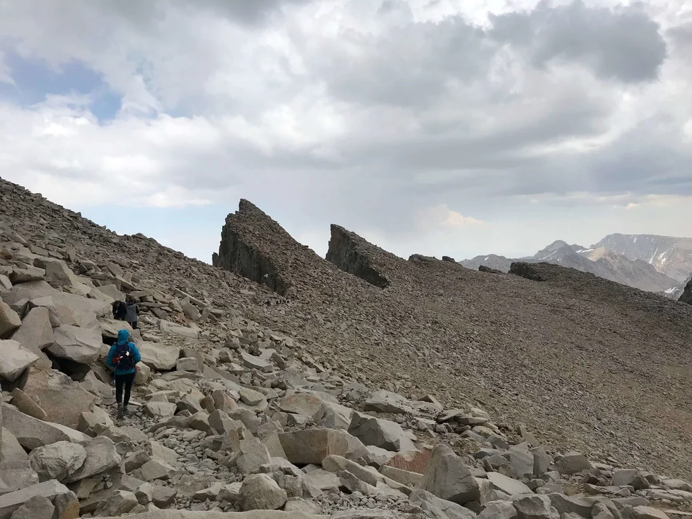
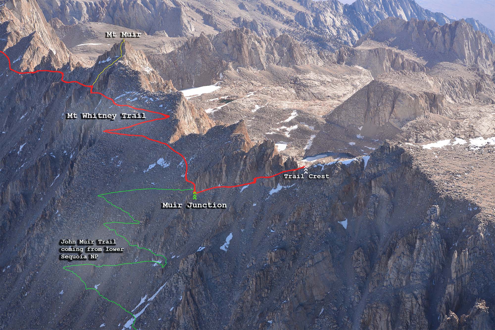
I tried to count the 99 Switchbacks while climbing them on a later trip. The crazy thing is that I got a different count on the way down that day. Whatever, I never got more than 97, but I guess 99 sounds cooler. Regardless, they are a b!tch. Once again, the psychological entered the picture. When the sun finally began to appear in the east, we could once again see the summit. That means that every time we got to the north end of one of the switchbacks, we saw pretty much the same thing as we had just seen a few minutes before. It never got closer. Back and forth, back and forth we went. The other guys just took off and disappeared. Lloyd laid back a little and would shout down encouragement from several switchbacks above, but eventually, he got summit fever and I told him to press on. I told him I may not be able to go all the way.
I was not feeling well. I had taken Diamox, a drug that is supposed to help with altitude sickness. On subsequent trips, I learned that it was not necessary. I never got sick or had a headache. I was just slow and had to rest frequently. I did not sleep well and don't know if it was because of the drug, the thin air, the tight quarters in the tent or the midnight pee breaks we semi-geezers had to take.
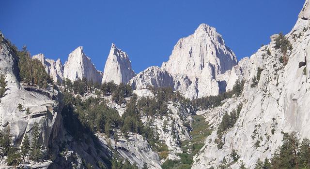
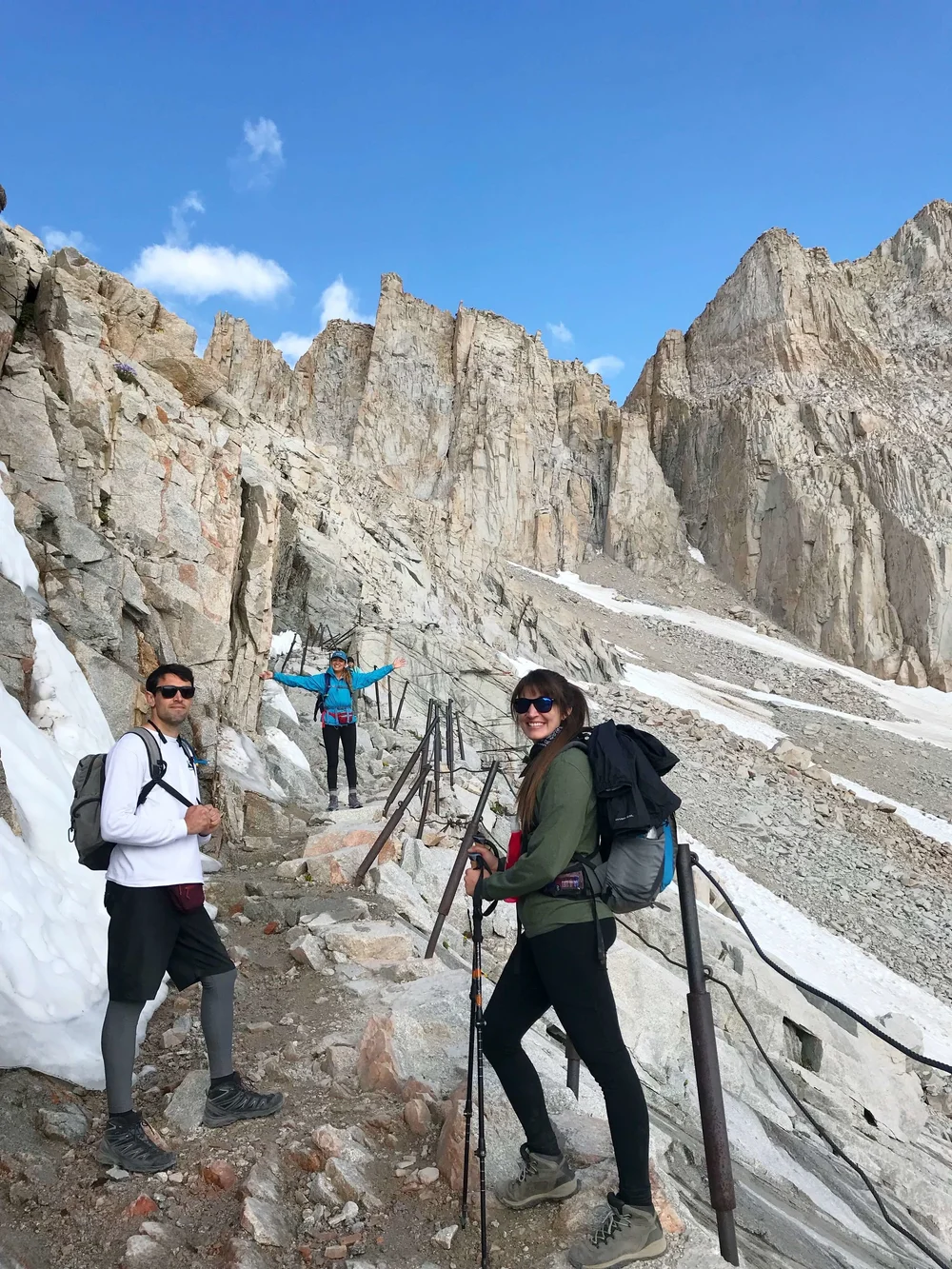
I finally made it to the cables. This is a place where the switchbacks bend around to face more to the north than the east. It is narrow, there is a rock wall to the left and a deadly fall to the right. The trail has rocks that are difficult to walk over and around and there is water seeping out of the wall that freezes on the trail that has been blasted into the wall. The cables are thin posts that have been sunk into the rock, with a thin cable running along the trail for a short distance. Frankly, I think it would be quite easy to slip under the cable and fall to your death. The cables are next to useless. I can say this with confidence, because I have read on the Whitney Portal Store Message Board, that this exact thing has occurred.
I learned later that one of the faster guys had sat down here and was going to call it a day, until one of the others teased him into pressing on. I will let you guess who those two were.
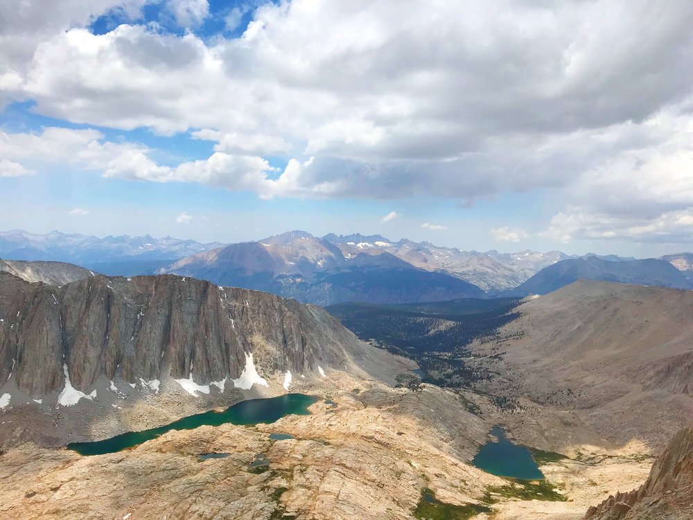
The view from Trail Crest was breath taking, to both sides. It was like standing on a knife edge. I could look back to Trail Camp and see the little pond from which we filtered our water and a tiny rectangular building that was difficult to see. That was the solar out house, which was also closed.
We all had eaten breakfast and done our morning necessities. Snake came back describing how nice and warm it felt to pick his up with the little plastic bags we had gotten at the ranger station. Consultation Lake was to the right.
I found a little rock ledge at Trail Crest, that was just the right height for me to sit on, as I enjoyed the views. I began to eat a Clif Bar and drink some water and Gatorade and suddenly, I began to feel better. This taught me that we can loose our appetite and sense of thirst at high elevations and therefore should plan to eat and drink at regular intervals, not wait until we are hungry and thirsty.
I was going to press on for another half mile, to the point where the John Muir Trail climbed up the western side of the ridge, to join the Mount Whitney Trail and continue to the summit. I knew that this would be a descent. I didn't know that it was steep and rocky and practically required a butt slide going down and a hands and feet scramble on the way back up. I did it in short time and when I got to the JMT, I felt well enough to press on. My thought was to go until one of the other guys passed on the way down and then turn back with them. I knew I would be faster going down.
Snake was the first I encountered and my brief discussion with him encouraged me to press on a little longer. The trail on the back side of the ridge is like nothing I have ever seen.


There is a sign in book at the hut and I have a picture somewhere of myself standing there, but Snake lost it.

OK, I found a way to get that photo, but Snake still lost my CD.
No comments:
Post a Comment