Lloyd had hiked to the summit of the highest mountain in Southern California, Mount San Gorgonio, via the South Fork of the Santa Ana River Trail. San Gorgonio is north of Palm Springs and is 11,500 ft. high. There are several trails to the summit and I have mentioned attempting the Vivian Falls Trail in the previous post. That was actually later than the hike in this story. I insisted that Lloyd join me on a hike using the South Fork Trail. He went for it.
https://goo.gl/maps/296akZT4mVdTQgYr7
I had a layover in Ontario CA coming up, that gave me enough time for the hike, or so I thought. I would fly into ONT from Rockford IL, get a few hours sleep, then meet Lloyd early enough to drive to the trailhead by 0600. Lloyd was on time off and jump seated there to meet me.
The weather was lousy that morning in the Inland Empire. We grabbed a quick breakfast and began driving east on I 10 (the 10) in the rain. As we began driving up California Highway 38, the rain became heavier and I could read Lloyd's mind. He was thinking I was crazy for doing this and that he was crazier for joining me.
https://goo.gl/maps/iCuv38aJnVsVosrFA
Then at about the spot where the map above begins, we broke out on top of the clouds. We could see the stars above and the tops of the clouds below. It was beautiful and I could hear Lloyd thinking, "Shit". It was just like what we often saw when climbing to our cruise altitude in the jet. I was relieved, but I think I would have wanted to hike even if it was in the rain. That would have added more to the dumbness than what we actually did.
When we parked and began donning our backpacks the sun was just beginning to let its existence be known to us. It was cool and we were only at about 6,000 feet elevation. We felt that we had plenty of time to hike to the summit and back.
We planned to follow the route that Lloyd had used before. He had hiked with a guy with whom he was flying. I remember him telling me that his buddy had gotten blackened toe nails as a result of boots that were improperly fitted. You can see that route as the blue line in the first map I linked to above. The gray line is an alternate route I will discuss later.
The hike up to the split was a nice walk in the woods. We passed a paved road and an old campground used by people who were passing through the mountains in this area. We passed a place called Poopout Hill. Not sure what that was all about. Maybe it was named by someone who got tired and ran out of gas. I saw no evidence to disprove that.
The trail was just a typical western mountain trail, with sand, rocks and roots to negotiate. No biggy. There was a creek near the split in the trail and we refilled our bottles. This was the last source of water and we still had many miles to go.
From that point, the trail gets steeper. The map shows only 9.6 miles to the summit that way, but it is actually more like 11 miles, because the map assumes only 2 dimensions and the third dimension is rough. It's like the hypotenuse of a right triangle. As we began climbing, the trail started to the south, then switched back to the north and then south again. As we rounded that turn to the south, we came upon a young man and woman. She was in the process of peeing on the side of the trail. We surprised them pretty good, but politely went back down the trail, around the bend.
Eventually, we came to the trail that went a short distance to Dollar Lake. I can remember Lloyd pointing to a spot above and saying it was Dollar Lake Saddle. From where we were to there looked like it was going to require a lot of switchbacks and it did. This was the difference between trails in the mountains of the West and those of the East. Back east, the trail designers didn't seem to understand the concept of switchbacks. It was as if they said, "There's a hill, let's go up there". Then they just went straight up, regardless of the steepness. I have experienced trails that were a hands and feet scramble going up and a butt slide going down. Unbelievabe. On western trails, there were so many switchbacks, you might cover 2 or 3 times the distance or more to get to a higher position. I think it was because the designers were being humane to the pack animals many of these trails were designed for.
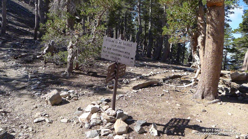
Dollar Lake Saddle was a big trail junction. The trail to the Gorgonio summit was to the left, a trail that went down to join the Vivian Falls trail was straight ahead and down and a trail westward to San Bernardino Peak went up and to the right. The elevation is 10,000 feet and I was beginning to feel the effects of not getting enough sleep and the thin air of high elevation. I remembered from my general aviation days, that the air density at 18,000 feet is half that of sea level, on a standard day. For example, an airplane engine that produced 400 horsepower at sea level, would produce only 200 at 18,000 ft., without a super charger, because of the thin air. The performance of a human would have a similar drop in efficiency, maybe worse.
I felt as if I needed a nap. Lloyd went along with all this. I tried to sleep, but it wasn't happening, so I got up and we pressed on. There was a geezer who we kept seeing on the trail. We would pass him, then he would pass us. Finally, he just kind of left us in the dust, because I was really dragging ass. I think that guy was going down a shorter trail from the top and having someone pick him up, so he wasn't worried about getting back to the same trailhead.
We weren't either, but we should have been. I was thinking that this would be my last time ever to attempt this hike and I wanted to get to the summit. I'm guessing Lloyd was and, in my fuzz brained way, I was crunching the time numbers and began to realize we were running out of time to do all that. I simply couldn't go any faster. When you do hikes like this, you have to make an educated guess as to how much time it takes to get back to your trailhead and establish a bingo time for climbing. When you get to that time, you turn back. We were blowing right through our bingo time, but not discussing it. Dumb.
Lloyd was feeling good and would press ahead, then wait for me. I began having weird micro-hallucinations. I would think I was seeing a rock or tree shake slightly, as if there was an earthquake. A couple times, I thought I saw Llyod's face hiding behind a bush. These were all the creations of a mind that was fatigued and starving for oxygen.
We reached Dry Lake View, which was the top of a cliff, from which you could look down to Dry Lake on the other trail to the summit. I'll bet you have already grasped the meaning of the name. This lake would fill with water during the Spring thaw and then dry up later in the summer.
From there, the trail traversed the ridge to the west. As we rounded the western shoulder of the ridge, there were ancient trees that bore the brunt of the winter winds at this high elevation. We were nearing 11,000 feet. We switched back to a southeasterly direction and would soon come to the short trail that led to the summit. There was a steep drop to the left, that was covered with snow. This made the air along that part of the trail very cold. If I remember correctly there was at least one false summit, where you see a crest ahead, think you are at the top, but when you get there, you can see that you have more to climb.
Shortly, we got there and looked around. We could see Palm Springs and Mount San Jacinto next to it.

I don't remember if it was clear enough at that time to see LA, probably not. There were several stone redoubts, which allowed setting up a campsite with protection from the wind. We were discussing our return hike.

Instead of going back the same way, Lloyd allowed me to talk him into going down the alternate route, which circled around to the east side of the mountain. It was a really cool trail, but this was a dumb decision. It was a little longer and we would encounter some situations that would delay us as we descended. I was able to make better time, but these delays were critical.
The first problem occurred just as we were passing south of the summit, as we looped around. Inexplicably, there was a snow field there on a shear face, with large boulders at the bottom. We could see that hikers had crossed before us, by the footprints in the snow. Because of the thaw/freeze cycle, the snow was more like little ice marbles. We started across very gingerly, being careful to test each step before putting full weight on that foot, using our trekking poles for extra security and being careful to lean into the mountain. We could see where a fast slide would end and it would have been disastrous. Long story short, we made it across, but it took us about 20 minutes to cross a section that we would have walked in 20 seconds, without the snowfield.

We rounded the corner to the east side of Gorgonio and began a steep descent. At 10,500 feet, we passed through a debris field of aluminum, that was above and below the trail. We were able to determine that this was the wreckage of a DC-3. Click the hyperlink to see some of the story and some photos. A C-47 is the military version of the DC-3.
We were descending, therefore gravity was now our friend, but it is necessary to be careful when descending. If you go too fast and fall, you have a greater angle of falling forward, than you do when ascending. If you lean back too much, your feet can slide out from under you on certain types of surfaces. The small rocks can be like little marbles. The thicker air was helping, but my fatigue was still slowing me down from my best forward speed.
As we approached Dry Lake, the terrain was flat for a while and we could hustle. When we exited the lake area, we entered into a canyon with steep rocky walls on both sides. This was where the runoff from the lake would have escaped.
Lloyd was still capable of moving much faster, so he stopped to do some map checking and knew he could catch me easily. I had been thinking about throwing my cheap backpack away, because by this time, it was becoming very uncomfortable.
I came around a bend, saw a big flat rock laying at about a 35 degree angle and some very quick movement of an animal that moved like a cat. It was a cat, a cougar cat. It must have been more startled than I and more able to do something about it than I. It jumped down off the rock, crossed the trail from right to left and disappeared silently into the woods. The hair on the back of my neck was standing up. I didn't have much reserve energy to do more. The only weapon I had was my trusty Swiss Army Knife. I took it out of my pocket and opened the largest blade.
I stood there for a few minutes until Lloyd arrived. I asked, "Did you see that?" "See what?", he asked. "That f**king cougar", I replied. "No", he responded. I described what I saw and where it went. I had told him about the micro-hallucinations I was having at the higher elevations, but said I didn't think I had just had another. We proceeded warily past the big rock and were on the alert for the next few miles, but that cat was probably long gone and had been more frightened than I was.
Approaching the point where the trails split, we could see that water was still running high in the creek. At that point we were a little concerned about crossing and getting wet, so we searched for an easy place to cross. Upstream a little, we found a fallen tree laying across and used that to get to the other side. Lloyd walked across, but I did not trust my balance and sat on it and kind of scooted across. We were able to refill out water bottles, for sure.
There was a mountain to the west of us on the next section of trail and we could see what we had refused to think about for the last several hours. It was going to get dark long before we could cover the distance back to the trailhead and our ride back to the hotel.
Because of the mountain to the west, the sun was setting early for us and we began to negotiate the rocks and roots along the trail in reducing light. As we approached Poop Out Hill again, we rested and discussed spending the night there. That idea was soon rejected and we pressed on, with Lloyd taking the lead, because he said he was more familiar with the trail. I could make out the difference in color or shade between the trail and not the trail and several times watched as Lloyd was heading for the rhubarb, off the trail. I took the lead, because it was apparent my night vision was better than his. I remembered my army training that it is better to use peripheral vision in the dark because of the location of the rods and cones on the retina.
Finally, we arrived at the paved road I mentioned earlier. We still had some distance to hike on the trail, but Lloyd had a plan he had been working on since just before the sighting of the cougar.
Since he could travel much faster than I, he would walk down this winding road to where it joined Jenks Lake Road. If you click the hyperlink, you will see the map. The trail to the South Fork Trailhead was shorter, but there were some hazards. It was windy and there were some steep drop-offs that would have been hard to see. Lloyd told me to walk down the road, following him and when I got to the gate on our road at Jenks Lake Road, wait there for him. He planned to walk ahead, get our rental and return to pick me up.
We were two airline pilots who had decided to do this big adventure and were not prepared to see in the dark. We had not brought lights. Lloyd did have a book of matches and showed me the map.
As I walked in the dark, I could barely see the road and was kind of depending on being able to feel the pavement under my feet. The map had indicated a few turns. After I thought I had made those few turns and should be at the gate, I began to wonder if I had walked off on another road without knowing. I could hear noises in the woods and was thinking my cougar pal might be stalking me. There was starlight and I could hear the far off voices of kids. That probably came from nearby scout camps. On and on I walked, for what seemed like too long.
Finally, I came to the gate. No Lloyd. I saw a big sign to the side of the road. I was very tired. I was wearing a ski parka and got down on the pavement, on my side and fell asleep. I don't know how long I slept, before my shoulder began to feel cold. I had compressed the layers of the parka and this woke me. I felt better and got up. Still no Lloyd. I began to worry. Was I saved from a cougar attack, because the cat had gotten Lloyd. Nah. I probably would have heard his screaming in that distinctive, unusually high, Lloyd voice.
He had told me about a night he was flying at UPS, when every time he called up on the radio, someone said, "Hi Lloyd". After about the third or fourth time, his first officer said, "Who are you?"
I paced to warm my self and worried. Finally I heard the unique voice calling my name in the dark. I responded. When we joined up, he told me his story. He had walked toward the trail head on Jenks Lake Road. He had the same experience I did. He soon thought he should have been there and worried that he had made a wrong turn. He used his last match to look at the map, walked a little more and decided to return to the gate. He did not believe the road was Jenks Lake Road going to the South Fork Trailhead.
I took him to the big sign and we could just barely make out the words Jenks Lake Road and South Fork Trail, with a big arrow pointing in the direction Lloyd had just returned from.
I said I felt revived from my little nap and we should walk together down Jenks Lake Road. He showed my where he stopped to light his last match and soon we came to the point where he turned back. I said, "Let's keep going."
I swear, we did not go 30 yards more and we could see the sign for the trailhead. Wow.
We got in the rental and as we drove back to our hotel in Riverside, I told Lloyd that I was done with these high mountain hikes. He looked relieved. We had been discussing a planned hike to Mount Whitney, the highest mountain in the US outside Alaska. You may remember that I mentioned learning about that back in the Pacific Express days. I think he was apprehensive about that and did not really want to do it.
We got to the hotel and I got a few hours sleep, before I had to get up to catch a jumpseat home on the 747. I was the only rider that night and had a big first class type seat. I fell asleep as soon as the wheels went in the well and slept until the landing woke me.
Later, as I was describing the Death March to my son, Mike, I told him I had decided to never do these hikes again, because of all the dumb things we had done. He said, "But look at all the things you learned." Hope. Look out Mount Whitney.
No comments:
Post a Comment